Mesoscale Alpine Programme (MAP & MAP D-PHASE)
The Mesoscale Alpine Programme (MAP) is a major international research initiative in the Alpine region. It aims towards better understanding and improved numerical prediction of atmospheric flow, precipitation, and hydrological processes in the Alpine region. Particular consideration is given to natural hazards such as heavy precipitation, flash flooding and wind storm events. The project culminated in a large international field campaign in the Alpine region in 1999 and a demonstration period of hydrological forecasting in 2007 (MAP D-PHASE). The project is linked with the World Weather Research Program (WWRP), and with the World Climate Research Program (WCRP) through the Global Energy and Water Cycle Experiment (GEWEX).
The project is a broad national and international project with dozens of participants. The Institute for Atmospheric and Climate Science is heavily involved in this project. ETH Zürich is hosting the MAP Data Center, which provides access to the field phase data. It is also playing an important role in (i) the observational activities relating to Föhn in the Rhine valley, (ii) field studies relating to the atmospheric boundary layer over complex terrain, (iii) the investigation of upper-level potential-vorticity streamers, (iv) the analysis of the Alpine wake structure, (v) the development of high-resolution atmospheric models, and (vi) the use of radar data to assess precipitation events.
Project website: external pagehttp://www.map.meteoswiss.ch
MAP D-PHASE
D-PHASE stands for "Demonstration of Probabilistic Hydrological and Atmospheric Simulation of flood Events in the Alpine region" and is a Forecast Demonstration Project (FDP) of the WWRP (World Weather Research Programme of WMO). It aims at demonstrating some of the many achievements of the Mesoscale Alpine Programme (MAP), in particular the ability of forecasting heavy precipitation and related flooding events in the Alpine region. The MAP FDP will address the entire forecasting chain ranging from limited-area ensemble forecasting, high-resolution atmospheric modelling (km-scale), hydrological modelling, and nowcasting to decision making by the end users, i.e., it is foreseen to set up an end-to-end forecasting system.
external pagehttp://www.map.meteoswiss.ch/map-doc/dphase/dphase_info.htm
Our contribution to MAP D-PHASE
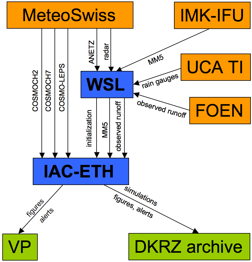
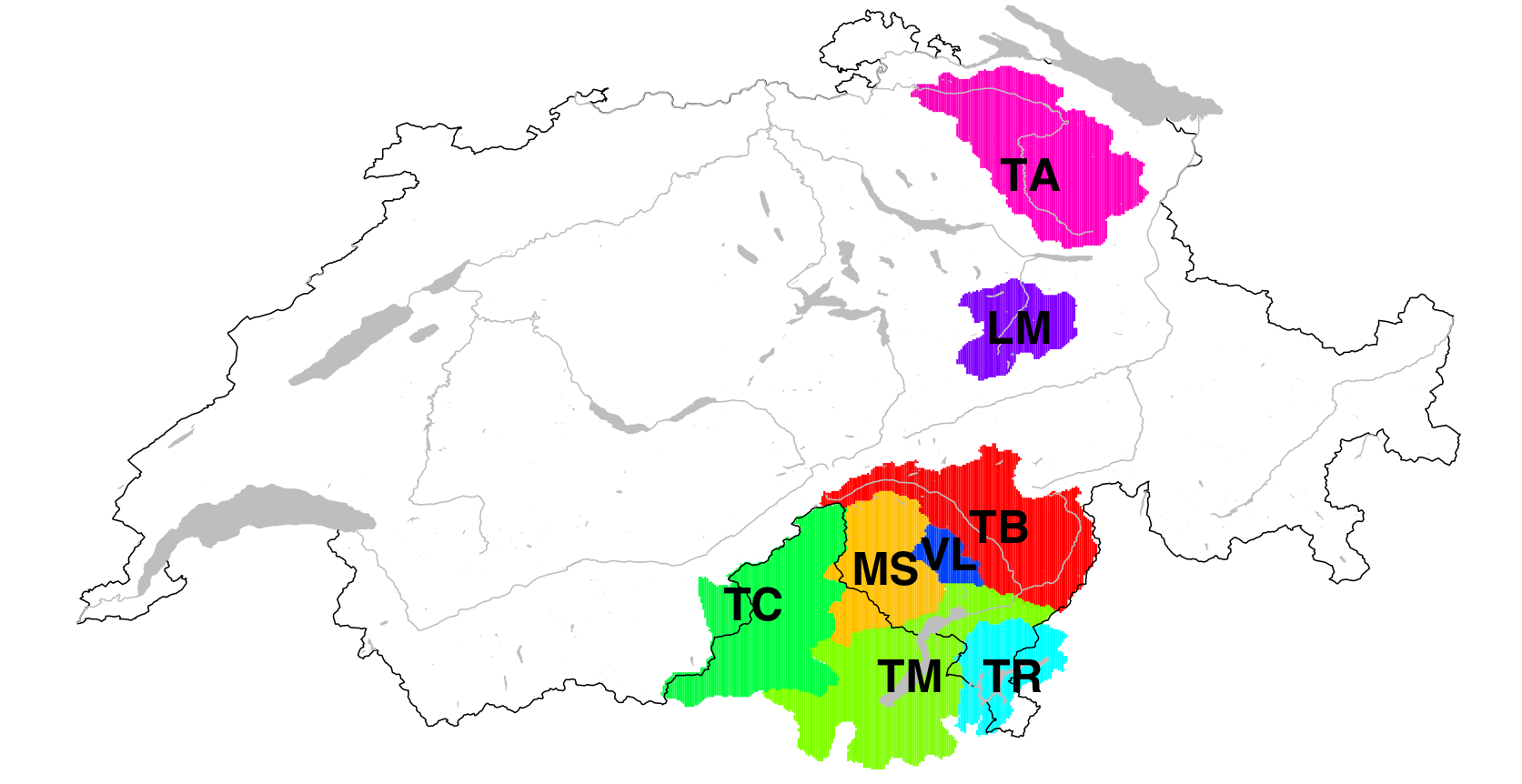
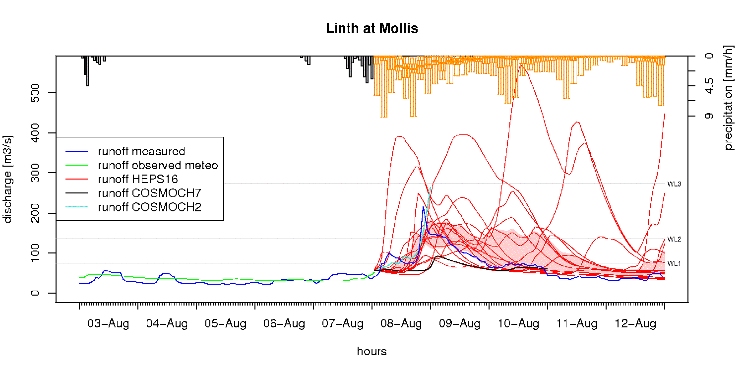
In collaboration with external pageWSL, we provide the following coupled hydrological forecast chain: An operational global atmospheric EPS (external pageECMWF EPS), dynamically downscaled with a limited-area atmospheric EPS (external pageCOSMO-LEPS), is used to drive the semi-distributed hydrological model external pagePREVAH. Daily forecasts with a range of 120 h, using a subsample of 16 ECMWF ensemble members selected by the COSMO-LEPS cluster analysis are conducted. Additionally, three deterministic forecast chains are implemented using a) the operational weather forecast from external pageMeteoSwiss (external pageCOSMO7, 7km gridspacing), b) an experimental implementation with 2km gridspacing of the same model (external pageCOSMO2) and c) external pageMM5 with 15km gridspacing provided by external pageIMK-IFU. The study area consists of 8 hydrological catchments, 6 of them covering the drainage area of the Lago Maggiore and 2 located north of the alps. The hydrological model runs at a spatial resolution of 500 meters and with hourly time steps. The application of this model framework during the MAP D-PHASE should help to explore possibilities, advantages and weaknesses of the hydrological EPS as well as of the simulations with atmospheric input at different spatial resolutions.
Publications
Benoit,R., C. Schär, P. Binder, S. Chamberland, H.C. Davies, M. Desgagné, C. Girard, C. Keil, N. Kouwen, D. Lüthi, D. Maric, E. Müller, P. Pellerin, J. Schmidli, F. Schubiger, C. Schwierz, M. Sprenger, A. Walser, S. Willemse, W. Yu and E. Zala, 2002. The real-time ultrafinescale forecast support during the Special Observing Period of the MAP. Bull. American Meteorol. Soc., 83, 85-109
Flamant C., E. Richard, C. Schär, R. Rotunno, L. Nance, M. Sprenger, and R. Benoit 2004: The wake south of the Alps: Dynamics and structure of the lee-side flow and secondary potential vorticity banners. Quart. J. Roy. Meteorol. Soc., 130, 1275-1303
Schär, C., M. Sprenger, D. Lüthi, Q. Jiang, R. B. Smith, and R. Benoit, 2003: Structure and Dynamics of an Alpine Potential Vorticity Banner, Quart. J. Roy. Meteorol. Soc., 129, 825-855
Walser, A., and C. Schär, 2004: Convection-resolving Precipitation Forecasting and its Predictability in Alpine River Catchments. J. Hydrol, 288, 57-73
Walser, A., D. Lüthi and C. Schär, 2004: Predictability of Precipitation in a Cloud-Resolving Model. Mon. Wea. Rev., 132 (2), 560-577