Climate Variability and Seasonal Forecasting in Central Asia

From a hydrological point of view, Central Asia is a region of exceptional interest and concern and it was the phenomenon of the desiccation of the Aral Sea that alerted a wider public to this fact. Water resources are strongly limited in general, but vary significantly between different seasons and areas of this semiarid region. This implies complex management tasks concerning the storage and distribution of water for its rational use in applications such as irrigation and hydropower generation. A sound understanding of the hydrological cycle is essential for a successful management of this kind. Such understanding, in turn, is unthinkable without reliable quantitative estimates of atmospheric precipitation as a key ingredient to hydrological or meteorological studies. A satisfactory estimation, however, is hampered by the far too low density of conventional observations. The situation has especially degraded since the decay of the Soviet Union as the young independent Central Asian countries face serious economic problems and cannot cope with maintaining the former observation network.
On one hand, this study aims at a better description and general understanding of the hydroclimatic variability in Central Asia. Issues addressed in this context include the representativeness of precipitation in different data sets, the role of the Indian summer monsoon, and the role of the Asian westerly jet. On the other hand, the application-oriented objective of this study is seasonal runoff forecasting in the Aral Sea basin.
To that aim, we are using observational data sets (e.g., external pageCRU, external pageGPCC), reanalyses (e.g., external pageERA-40, external pageNCEP) and regional climate simulations. We have set up the regional climate model CHRM over a Central Asian domain and conducted multi-decadal simulations. Our runoff forecasting system is based on multiple linear regression models to forecast summer runoff in the Amudarya and Syrdarya rivers. As input for the statistical models, we are testing the suitability of data sets from the European Center for Medium-Range Weather Forecasts (ECMWF), i.e. the ERA-40 reanalysis (available for the time period 1958-2001 at low spatial resolution), the ECMWF operational analysis (available in real time at high spatial resolution), and output of the CHRM model (available both in real time and at even higher spatial resolution).
Comparison of reanalyses, direct observations and numerical downscaling indicate that all data sets agree on the horizontal distribution of precipitation on scale larger than about 300 km (see Schiemann et al. 2007a). The observations usually agree qualitatively on the occurrence of anomalous years or seasons, while there is considerable disagreement regarding the amplitude of interannual variability. The regional climate model is capable of improving the spatial distribution of precipitation. At the same time, the CHRM (as well as ERA-40) underestimates summer precipitation and its variability, while interannual variations are well represented during the other seasons, in particular in the Central Asian mountains during winter and spring.
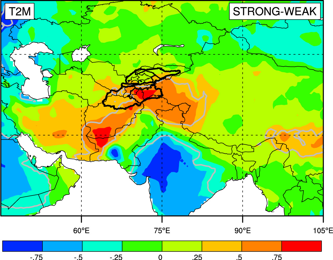
Concerning runoff formation, snowmelt represents the dominant contribution to the river flow and freshwater supply during the summer season. However, we could also find a significant correlation between the intensity of the Indian Summer Monsoon (ISM) and runoff: strong ISM causes anomalies in surface temperatures (see Fig. 2) and thus in meltwater formation and runoff (Schiemann et al. 2007b).
As runoff primarily relies on meltwater formation, where the observational density is far too low while reanalyses and regional climate simulations perform comparatively well, the prospects of using numerical downscaling as input for statistical runoff models are promising. A preliminary analysis in the Syrdarya source region (166,000 km2, see Fig. 1) demonstrated that our runoff forecasting system has a high potential (Schär et al. 2004). Runoff forecasts for the region and the vegetation period April-September, which are produced in joint collaboration with the Hydrometeorological Service in Tashkent (Uzbekistan), can be accessed here.
Publications:
Schiemann, R., D. Lüthi, P. Vidale, and C. Schär, 2008: The precipitation climate of Central Asia - intercomparison of observational and numerical data sources in a remote semiarid region. Int. J. Climatol., 28, 295-314
Schiemann, R., M. G. Glazirina, and C. Schär, 2007: On the relationship between the Indian summer monsoon and river flow in the Aral Sea basin, Geophysical Reserach Letters, 34, L05706, doi:10.1029/2006GL028926.
Schär, C., L. Vasilina, F. Pertziger, and S. Dirren, 2004: Seasonal runoff forecasting using precipitation from meteorological data assimilation systems, J. Hydrometeorol., 5, 959-973.